Hiking Trails
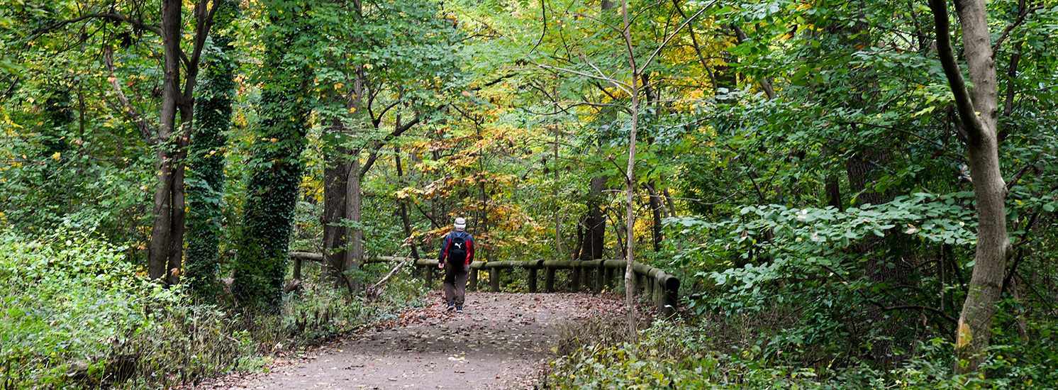
Happy trails await you in a New York City park. Pick a trail based on preferred difficulty, distance, or scenery; pack plenty of water and sunscreen; layer your clothing; and hit the road! Looking to join a group hike with a guide? Visit our Hiking Events page.
Recommended Hiking Trails
Plan your next hiking trip right here in New York City! Check out our new interactive trail maps and favorite trails
![]() indicates Accessible Facilities
indicates Accessible Facilities![]() indicates Limited Access Facilities
indicates Limited Access Facilities
Locations
Alley Pond Park Hiking Trails
Location: Alley Pond ParkCheck out our Alley Pond Park Trails page for a map and directions to scenic locations.
Park Name: Alley Pond Park
Length: Various
Difficulty: Various
Other Details: Numerous trails wind through native hardwood (oak-hickory) forest and kettle ponds. The north end of the park boasts splendid salt marsh views.
ParkName: Alley Pond Park
Bayswater Park Hiking Trails
Location: Bayswater ParkCheck out our Bayswater Trails page for a map featuring entrances and directions to scenic locations.
Park Name: Bayswater Park
Length: 0.25 miles
Difficulty: Moderate
Other Details: From the playground of Bayswater Park, follow the painted signs on the ground into the fields. Where the Sidewalk ends, across the field a large wooden post marks the beginning of the trail.
ParkName: Bayswater Park
Broad Channel American Park & Sunset Cove Park Hiking Trails
Location: Broad Channel American Park (near Sunset Cove Park)The Broad Channel American Park and Sunset Cove trails offer stunning views of the Manhattan skyline and includes over 15 acres of Forever Wild areas.
Check out our Broad C
Park Name: Broad Channel American Park & Sunset Cove Park
Length: 0.5 mile
Difficulty: Easy
Other Details: A waterfront marina with various acres of maritime upland and salt marshes.


Dubos Point Wildlife Preserve Hiking Trails
Location: Dubos Point Wildlife Sanctuary60-3 De Costa Ave, Arverne, NY 11692
Park Name: Jamaica Bay Park
Difficulty: Easy
Other Details: Immerse yourself into this salt marsh sanctuary, bring your binoculars, and see the natural beuaty of Jamaica Bay. Check out our Dubos Point Wildlife Preserve Trails page for a map featuring entrances and directions to scenic locations.
ParkName: Dubos Point Wildlife Sanctuary
Forest Park Hiking Trails
Location: Forest ParkCheck out our Forest Park Trails page for a map and directions to scenic locations.
Park Name: Forest Park
Length: Various
Difficulty: Various
Other Details: There are many parks with forests in NYC, but only one Forest Park! Numerous trails wind through native hardwood (oak-hickory) forest and kettle ponds in the park, home to the continuous oak forest in the city. Discover a century-old pine grove on the orange trail, go birding at Strack Pond on your way through the red trail, and check out some of the park's historic sites, including the Richmond Hill War Memorial and The Carousel.
Check out our Forest Park Trails page for a map and directions to scenic locations.
ParkName: Forest Park
Highland Park Hiking Trails
Location: Highland ParkCheck out our Highland Park Trails page for a map and directions to scenic locations.
Park Name: Highland Park
Length: Various
Difficulty: Various
Other Details: Atop a plateau, Highland Park’s trails offer unique, elevated views of the forests and surrounding neighborhoods. Pass by the remaining infrastructure from the former Ridgewood Reservoir can still be seen, an area where many birds now visit as they migrate along the Atlantic Flyway.
ParkName: Highland Park
Jamaica Bay Park Hiking Trail
Location: Jamaica Bay ParkCheck out our Jamacia Bay Park Trails page for a map featuring entrances and directions to scenic locations.
Park Name: Jamaica Bay Park
Length: Various
Other Details: Jamaica Bay is an 18,000-acre wetland estuary surrounded by the Rockaway Peninsula to the South, Brooklyn to the West, and Queens to the East.
ParkName: Jamaica Bay Park
Kissena Park & Kissena Corridor Hiking Trails
Location: Kissena Park (near Kissena Corridor Park)Check out our Kissena Park Trails page for a map and directions to scenic locations.
Park Name: Kissena Park / Kissena Corridor
Length: Various
Difficulty: Various
Other Details: Explore the network of nature trails in this wooded oasis, connecting Kissena Park and the reforested area in Kissena Corridor.
ParkName: Kissena Park
Rockaway Community Park Hiking Trails
Location: Rockaway Community ParkThe Rockaway Community Park hiking trail is continuously being restored and offers scenic views of Jamaica Bay.
Check out our Rockaway Community Park Hiking Trails page for a map and di
Park Name: Rockaway Community Park
Length: Various
Difficulty: Medium
Other Details: A natural preserve offering scenic wetlands, walking trails, and abundant bird watching opportunities along the shores of Jamaica Bay
South Preserve Trails
Location: Cunningham ParkFrancis Lewis Boulevard and Union Turnpike
Park Name: Cunningham Park
Length: 3.0 miles
Other Details: Numerous unnamed trails wind through native hardwood (oak-hickory) forest, which features a diverse ecosystem to support abundant wildlife. The parks’ Kettle Ponds feature the sounds of Spring Peepers and other species of frogs throughout the spring and summer season.
Check out our Cunningham Park Trails page for a map and directions to scenic locations.
ParkName: Cunningham Park
Udalls Park Preserve Hiking Trails
Location: Udall's Park PreserveCheck out our Udalls Park Preserve Trails page for a map and directions to scenic locations.
Park Name: Udalls Park Preserve
Length: Various
Difficulty: Various
Other Details: Wind through this wetland preserve on one of several hiking trails, passing salt grasses, wooded uplands, and the placid waters of Aurora Pond. Visitors can see snowy egrets, osprey, foxes, and more wildlife neighbors that make their home and search for food around the salt marsh.
ParkName: Udall's Park Preserve
Willow Lake Hiking Trails
Location: Flushing Meadows Corona ParkCheck out our Willow Lake Trails page for a map featuring entrances and directions to scenic locations.
Park Name: Flushing Meadows Corona Park
Difficulty: Easy
Other Details: Hikers can access the trail from the east at the Van Wyck Expressway overpass at Mauro Playground (73rd Terrace and Park Drive East) and from the west at 72nd Road and the Grand Central Parkway Service Road.
ParkName: Flushing Meadows Corona Park
Allison Pond Park & Goodhue Park
Location: Goodhue ParkCheck out our Allison Pond Park & Goodhue Park Trails page for a map and directions to scenic locations.
Park Name: Allison Pond Park & Goodhue Park
Length: various
Difficulty: various
Other Details: Along these two adjacent parks with one connected trail network you will find wooded upland hillsides with habitats for small mammals. Hike through over nine acres of Forever Wild natural areas and discover a remnant of the Wisconsin glacier.
ParkName: Goodhue Park
Arden Woods Hiking Trails
Location: Arden WoodsCheck out our Arden Woods Park Trails page for a map and directions to scenic locations.
Park Name: Arden Woods
Length: Various
Difficulty: Various
Other Details: Hooting and singing is often heard along these trails, frequented by owls and migratory birds. Pass by kettle ponds and wetlands, under a canopy of white oak, maple, sweet gum, and more trees.
ParkName: Arden Woods
Bloomingdale Park Hiking Trails
Location: Bloomingdale ParkThe Bloomingdale Park trails have rare pine species and great biodiversity.
Check out our Bloomingdale Park Hiking Trails page for a map and directions to scenic locations.
Park Name: Bloomingdale Park
Length: 2 miles
Difficulty: Various
Other Details: 2 trails that offer numerous signs of amphibian wildlife including salamanders and frogs.
Blue Heron Park Trails
Location: Blue Heron ParkCheck out our Blue Heron Park Trails page for a map and directions to scenic locations.
Park Name: Blue Heron Park
Length: Various
Difficulty: Various
Other Details: Escape into a natural oasis, passing freshwater wetlands, kettle ponds, fields of wildflowers, and successional forests in this protected natural area, home to the namesake great blue heron and more stunning wildlife.
ParkName: Blue Heron Park
Brady's Pond Park Hiking Trails
Location: Bradys Pond ParkThe Brady’s Pond Park hiking trail offers scenic birding spots and water sports.
Check out our Brady’s Pond Park Hiking Trails page for a map and directions to scenic locati
Park Name: Brady's Pond Park
Length: Various
Difficulty: Various
Other Details: Offers clear viewing spots for waterfowl and endless lake activities
ParkName: Bradys Pond Park
Brookfield Park Hiking Trails
Location: Brookfield ParkThe Brookfield Park trails show the beauty of a restored Mid Island Gem with various trails that include many native plantings.
Check out our Brookfield Park Hiking Trails page for a map and direct
Park Name: Brookfield Park
Length: 4 miles
Difficulty: Various
Other Details: Four easy marked trails that offer beautiful views of Richmond creek, many native plantings, and paths that encircle wetlands, rivers, ponds, and marshes
Clove Lakes Park Trail
Location: Clove Lakes ParkVictory Boulevard
Park Name: Clove Lakes Park
Length: 3.0 miles
Difficulty: Easy
Other Details: Visitors can enjoy walks by its valley lakes, ascend pathways through wooded hills, pause along its picturesque bridges, or visit New York City’s largest tulip tree.
ParkName: Clove Lakes Park
Conference House Park Hiking Trails
Location: Conference House ParkCheck out our Conference House Park Trails page for a map and directions to scenic locations.
Park Name: Conference House Park
Other Details: The Conference House Blue Trail extends from Shore Road and Satterlee Street all the way south to Brighton Street and Surf Avenue. Along the way, you can see a number of historic buildings, including the famed Conference House, and enjoy beautiful waterfront views of this beachside park.
ParkName: Conference House Park
Eibs Pond Park Hiking Trails
Location: Eibs Pond ParkPark Name: Eibs Pond Park
Length: 0.5 mile
Difficulty: Easy
Other Details: Eibs Pond Park serves as habitat for over 80 bird species, including snowy egrets. The clay-bottomed pond itself covers three acres, making it the largest kettle pond in New York City.
Fairview Park Hiking Trails
Location: Fairview ParkCheck out our Fairview Park Trails page for a map and directions to scenic locations.
Park Name: Fairview Park
Length: Various
Difficulty: Various
Other Details: Traverse a restored forest with pin oak, sassafras, and American Sycamore trees, plus enjoy views of the Outerbridge Crossing, and a vernal pond, home to many wildflowers and pollinators.
ParkName: Fairview Park
Greenbelt Hiking Trails
Location: Blood Root Valley (near Latourette Park & Golf Course, Freshkills Park, Willowbrook Park, Richmond Parkway, High Rock Park, Deere Park, Reed's Basket Willow Swamp Park, Manor Park)Check out our Greenbelt Trails page for a map and directions to scenic locations.
Park Name: The Greenbelt
Length: Various
Difficulty: Various
Other Details: The Greenbelt is a 2,800-acre group of parks in the heart of Staten Island. It includes Blood Root Valley Park, Deere Park, High Rock Park, LaTourette Park, Manor Park, Reeds Basket Willow Swamp Park, Willowbrook Park, Richmond Parkway, and the William T. Davis Wildlife Refuge. More than 35 miles of trails offer opportunities for exploration and respite in The Greenbelt's network of diverse ecosystems, home to NYC's largest remaining forest preserve! Discover beautiful scenic locations as you journey past our tidal and freshwater wetlands, beech forests, and open meadows and ascend two of the highest points along the east coast at Heyerdahl Hill and Paulo's Peak (a 200-foot-tall mountain that offers a 360-degree view of The Greenbelt).
Check out our Greenbelt Trails page for a map and directions to scenic locations.
ParkName: Blood Root Valley
Jones Woods Park Hiking Trail
Location: Jones Woods ParkCheck out our Jones Woods Park Trails page for a map and directions to scenic locations.
Park Name: Jones Woods Park
Length: 0.26 miles
Difficulty: Moderate
Other Details: Explore the Serpentine Barrens ecosystem. Found in only a few places in the world, in New York this unique ecosystem is found only on Staten Island.
ParkName: Jones Woods Park
King Fisher Park Hiking Trails
Location: King Fisher ParkThe King Fisher hiking trails passes along upland forest landscapes and is home to the park’s namesake the belted kingfisher.
Check out our King Fisher Hiking Trails page for a map and directi
Park Name: King Fisher Park
Length: Various
Difficulty: Various
Other Details: Home to upland forest, wetland pond shores, and trails lined with soft native sedges. Keep an eye out for the Belted Kingfisher bird.
Long Pond Park Hiking Trails
Location: Long Pond ParkThe Long Pond Park hiking trail is the largest continuous natural area that is habitat for many endangered species.
Check out our Long Pond Park Hiking Trails page for a map and directions to sc
Park Name: Long Pond Park
Length: 2.25 miles
Difficulty: Various
Other Details: A nature preserve featuring diverse woodlands and wetlands which was formed by receding glaciers and serving as a vital stopover for migratory birds.
Ocean Breeze Park Hiking Trails
Location: Ocean Breeze ParkCheck out our Ocean Breeze Park Trails page for a map and directions to scenic locations.
Park Name: Ocean Breeze Park
Length: Various
Difficulty: Various
Other Details: Explore protected wetlands, a shrub forest, and scenic views on the Blue and Orange Loop Trails at Ocean Breeze Park, home to wild turkeys, Canada geese, and deer! Be sure to take in the beauty of the South Beach Wetlands from the Blue Loop Trail. The Orange and Blue trails loop together to create a 5K Cross-Country Course used for runners during outdoor track & field season.
Check out our Ocean Breeze Park Trails page for a map and directions to scenic locations.
ParkName: Ocean Breeze Park
Siedenburg Park Hiking Trails
Location: Siedenburg ParkThe Siedenberg Park hiking trail contains upland forests, seasonal ponds and streams, and a 3.5-acre lake, making it the perfect place for birding.
Check out our Siedenberg Park Hiking Trails page fo
Park Name: Siedenburg Park
Length: Various
Difficulty: Easy
Other Details: This natural area is a boon for local birders and hikers. Park is home to oak forests and a central swamp, which is home to herons, egrets, and many other birds
Willowbrook Park White Trail
Location: Willowbrook ParkWillowbrook Park off Victory Boulevard
Park Name: Willowbrook Park
Length: 7.6 miles
Difficulty: Easy/Moderate
Other Details: Connects to Great Kills Park of the Gateway National Park System Service.
ParkName: Willowbrook Park
Wolfe's Pond Park Hiking Trails
Location: Wolfe's Pond ParkThe Wolfe’s Pond Park hiking trails offer various distances for all skill levels along with rich views of elevation from below and above.
Check out our Wolfe’s Pond Park Hiking T
Park Name: Wolfe's Pond Park
Length: Various
Difficulty: Various
Other Details: Staten Island's largest park that includes a beach, wildlife preserve, and recreation area.
ParkName: Wolfe's Pond Park
Wolfe's Pond Trail
Location: Wolfe's Pond ParkHylan Boulevard & Cornelia Avenue
Park Name: Wolfes Pond Park
Length: 0.75 miles
Difficulty: Easy
Other Details: Both hikers and mountain bikers can explore miles of trails in this south shore location. Trails contain easy, moderate, and difficult terrain.
ParkName: Wolfe's Pond Park
Bronx River Forest Hiking Trails
Location: Bronx ParkEnter at East Gun Hill Road for Red Trail and Burke Avenue or East 204th St. for Blue Trail
Park Name: Bronx Park
Other Details: The Bronx River Forest trails offer a river respite from the busy Bronx nearby.
Check out our Bronx River Forest Trails page for a map and directions to scenic locations.
ParkName: Bronx Park
Pelham Bay Park Hiking Trails
Location: Pelham Bay ParkCheck out our Pelham Bay Park Trails page for a map and directions to scenic locations.
Park Name: Pelham Bay Park
Length: Various
Difficulty: Various
Other Details: Leave the city far behind as you explore the trails of NYC's largest park! It's hard to believe you're still in New York City while exploring miles of trails that wind through some of the oldest oak trees and journey to sweeping shoreline views from the peninsula while offering opportunities to discover the park's nature treasures — the picturesque The Twin Islands, the marsh and tidal inlet at Turtle Cove, the historic Lagoon, a nature sanctuary at Hunter Island, a famous glacial boulder, and, of course, Orchard Beach!
Check out our Pelham Bay Park Trails page for a map and directions to scenic locations.
ParkName: Pelham Bay Park
Pugsley Creek Park & Castle Hill Park Hiking Trails
Location: Pugsley Creek Park (near Castle Hill Park)Check out our Pugsley Creek Park & Castle Hill Park Trails page for a map and directions to scenic locations.
Park Name: Pugsley Creek Park
Length: 1.2 miles
Difficulty: Easy
Other Details: Trace a maritime forest around Pugsley Creek, and pause at scenic outlooks offering views of the water, the Whitestone and Throgs Neck bridges, salt marsh, and air traffic at LaGuardia Airport.
ParkName: Pugsley Creek Park
Seton Falls Park Hiking Trails
Location: Seton Falls ParkCheck out our Seton Falls Park Trails page for a map and directions to scenic locations.
Park Name: Seton Falls Park
Length: Various
Difficulty: Various
Other Details: Explore the "Grand Canyon of the Bronx"! Discover a floodplain forest and scenic overlooks of the Rattlesnake ravine and falls as you venture through 130 acres of natural forest and recreational space along our three hiking trails: the Orange Nature Path, the Blue Scenic Through Trail, and the Red "Loop" Trail.
Check out our Seton Falls Park Trails page for a map and directions to scenic locations.
ParkName: Seton Falls Park
Soundview Park Hiking Trails
Location: Soundview ParkCheck out our Soundview Park Trails page for a map and directions to scenic locations.
Park Name: Soundview Park
Length: 1.75 miles
Difficulty: Easy
Other Details: Sitting where the Bronx River opens into the East River, Soundview Park offers waterfront views, with trails winding through both the natural and built environment, passing the Soundview Amphitheater, a butterfly meditation garden, grasslands, and more.
ParkName: Soundview Park
Spuyten Duyvil Park Hiking Trails
Location: Spuyten Duyvil Shorefront ParkCheck out our Spuyten Duyvil Park Trails page for a map and directions to scenic locations.
Park Name: Spuyten Duyvil Park
Length: .25 miles
Difficulty: Easy
Other Details: Passing under the Henry Hudson Bridge, this trail offers views of the Hudson River as well as a natural spring and freshwater pond which feed the river, and an array of shorebirds that call the area home.
ParkName: Spuyten Duyvil Shorefront Park
Van Cortlandt Park Hiking Trails
Location: Van Cortlandt ParkCheck out our Van Cortlandt Trails page for a map and directions to scenic locations.
Park Name: Van Cortlandt Park
Length: Various
Difficulty: Various
Other Details: Immerse in the beauty of nature in NYC's third largest park! Journey through three ecologically distinct forests on a 2-mile trail at the northern end of the park and past freshwater wetlands and a lake area perfect for birding in the heart of the park. Get a glimpse of history as you discover remnants of the Old Croton Aqueduct and visit the Grand Central Stones. Be sure to head out on the Putnam Trail, a paved pathway that travels from the southern to the northern end of the park and connects to the South County Trailway, so you can extend your hike into Westchester!
Check out our Van Cortlandt Trails page for a map and directions to scenic locations.
ParkName: Van Cortlandt Park
Canarsie Park Hiking Trail
Location: Canarsie ParkCheck out our Canarsie Trails page for a map featuring entrances and directions to scenic locations.
Park Name: Canarsie Park
Length: 0.5 miles
Difficulty: Easy
Other Details: The Canarsie blue loop trail is just over half a mile long and circles the wetland area at the eastern side of Canarsie Park.
ParkName: Canarsie Park
Fresh Creek Nature Preserve Hiking Trails
Location: Fresh Creek Nature PreserveCheck out our Fresh Creek Nature Preserve Trails page for a map and directions to scenic locations.
Park Name: Fresh Creek Nature Preserve
Length: 1 mile
Difficulty: Easy
Other Details: Wind past a 42-acre salt marsh. Take in the beauty of the preserve and some of the 325 species of birds that visit Jamaica Bay every year, along with butterflies, aquatic life, and native salt marsh plants.
ParkName: Fresh Creek Nature Preserve
Lullwater
Location: Prospect ParkEnter Park at Lincoln Road and Ocean Avenue entrance. Trails begin or are near the Prospect Park Audubon Center.
Park Name: Prospect Park
Length: 1.0 mile
Difficulty: Easy
Other Details: Explore the Lullwater to see how nature thrives in the heart of Brooklyn. The Lullwater is a great place to see birds and other wildlife. Bathrooms, café and trail guides are available at the Prospect Park Audubon Center.
ParkName: Prospect Park
McGuire Fields Park Hiking Trails
Location: Mcguire FieldsCheck out our McGuire Fields Park Trails page for a map and directions to scenic locations.
Park Name: McGuire Fields Park
Length: Various
Difficulty: Various
Other Details: The Park’s diverse habitat and position along the Atlantic Flyway make these trails a perfect spot for bird watching, plus enjoy sweeping vistas of Paerdegat Basin and the lower Manhattan Skyline.
ParkName: Mcguire Fields
Midwood
Location: Prospect ParkEnter Park at Lincoln Road and Ocean Avenue entrance. Trails begin or are near the Prospect Park Audubon Center.
Park Name: Prospect Park
Length: 0.75 miles
Difficulty: Easy
Other Details: Step back in time with a walk through Brooklyn’s oldest remaining forest. The Midwood, home to some of Prospect Park’s largest trees, is a relic of Brooklyn’s history, and was preserved and incorporated into the park during its original construction. The thirty-minute hike loops from Prospect Park’s Audubon Center through a forest filled with birds and other animals.
ParkName: Prospect Park
Paerdegat Basin Hiking Trails
Location: Paerdegat Basin ParkCheck out our Paerdegat Basin Trails page for a map featuring entrances and directions to scenic locations.
Park Name: Paerdegat Basin Park
Difficulty: Moderate
ParkName: Paerdegat Basin Park
Peninsula
Location: Prospect ParkEnter Park at Lincoln Road and Ocean Avenue entrance. Trails begin or are near the Prospect Park Audubon Center.
Park Name: Prospect Park
Length: 0.5 miles
Difficulty: Easy
Other Details: Discover how the Peninsula has changed over the last 300 years. The Peninsula's restored landscapes provide scenic views, a home for Park wildlife, and great fishing. Bathrooms, café and trail guides are available at the Prospect Park Audubon Center.
ParkName: Prospect Park
Prospect Park Hiking Trails
Location: Prospect ParkCheck out our Prospect Park Trails page for a map featuring entrances and directions to scenic locations.
Park Name: Prospect Park
Length: Various
Difficulty: Various
Other Details: Explore Brooklyn's last remaining upland forest, pollinator meadows, wetland kettles, streams, waterfalls, and more in the 250 acres of idyllic natural areas as designed by Olmsted and Vaux
ParkName: Prospect Park
Salt Marsh Nature Trails
Location: Marine ParkEnter behind the Salt Marsh Nature Center, located near the intersection of East 33rd Street and Avenue U.
Park Name: Marine Park
Length: 0.8 miles
Other Details: The first half of this mile-long trail follows the shore of Gerritsen Beach, which empties into Jamaica Bay. The trail’s second leg winds through a prairie of tall grass, where you can sometimes spot cottontail rabbits and ring-necked pheasants.
Check out our Marine Park Trails page for a map and directions to scenic locations, and comfort stations and maps are also available inside the Salt Marsh Nature Center.
Spring Creek Park Hiking Trails
Location: Spring Creek ParkCheck out our Spring Creek Park Trails page for a map and directions to scenic locations.
Park Name: Spring Creek Park
Length: 1.2 miles
Difficulty: Easy
Other Details: Stroll through marshland in the largest tract of undeveloped land and wetlands in the northern Jamaica Bay area, and see the many wildlife species that call this open greenery home.
ParkName: Spring Creek Park
Waterfall
Location: Prospect ParkEnter Park at Lincoln Road and Ocean Avenue entrance. Trails begin or are near the Prospect Park Audubon Center.
Park Name: Prospect Park
Length: 0.5 miles
Difficulty: Easy
Other Details: Trace the source of the Lake on the Waterfall trail. The Fallkill Falls is the first of six waterfalls that you will see along the Park's watercourse. Bathrooms, café and trail guides are available at the Prospect Park Audubon Center.
ParkName: Prospect Park
Fort Tryon Park Hiking Trails
Location: Fort Tryon ParkCheck out our Fort Tryon Park Trails page for a map and directions to scenic locations.
Park Name: Fort Tryon Park
Length: Various
Difficulty: Various
Other Details: Travel through time, passing the remnants of New York City’s largest glacial pothole, the medieval architecture of the Met Cloisters, and Columnade by Eduardo Ramirez Villamizar, a contemporary sculptural installation. Enjoy stunning, manicured landscape in the park and magnificent, carefully preserved views looking out at the Hudson River and the Palisades.
ParkName: Fort Tryon Park
Fort Washington Park Hiking Trails
Location: Fort Washington ParkCheck out our Fort Washington Park Trails page for a map featuring entrances and directions to scenic locations.
Park Name: Fort Washington Park
Length: Various
Difficulty: Various
Other Details: Walk through nature and history with views of the George Washington Bridge, the iconic Palisades, a Red Oak Heath forest, and the Hudson River, plus the American Redoubt Marker, the site of the western end of an American Revolution fortification that included Fort Washington.
ParkName: Fort Washington Park
Highbridge Park Hiking Trails
Location: Highbridge ParkCheck out our Highbridge Park Trails page for a map and directions to scenic locations.
Park Name: Highbridge Park
Length: Various
Difficulty: Various
Other Details: Commune with nature as you hike through the forests of this beautiful park that looks out to the Harlem River and the oldest standing bridge in New York City! Discover native and introduced trees, such as black cherry, northern oaks, and Virginia creepers, and delve into the park's history of supplying clean water to the city during the 19th century as you hike the Old Croton Aqueduct Trail. Look to the skies — Highbridge Park's forested areas and waterfront make for an ideal location for spotting hawks.
Check out our Highbridge Park Trails page for a map and directions to scenic locations.
ParkName: Highbridge Park
Inwood Hill Park Hiking Trail
Location: Inwood Hill ParkCheck out our Inwood Hill Trails page for a map featuring entrances and directions to scenic locations.
Park Name: Inwood Hill Park
Difficulty: Moderate
Other Details: Take a step back in time and imagine Manhattan as a forest grove of tulip trees, oaks, and maples. Inwood Hill Park's marked scenic sites or historic highlights trail will lead you to the top of the hill, where the park's oldest trees—two Cottonwoods planted before the park was established—still live.
ParkName: Inwood Hill Park
Riverside Park Hiking Trail
Location: Riverside ParkCheck out our Riverside Park Trail page for a map featuring entrances and directions to scenic locations.
Park Name: Riverside Park
Length: Various
Difficulty: Easy-Moderate
Other Details: Savor the scenery alongside birds and pollinators! Pass through the Bird Sanctuary, which provides safe haven for many species, including the red bellied woodpecker, American robin, and tufted titmouse, then visit the Pollinator Meadow which, an important habitat for pollinators, full of nectar-rich plants.
ParkName: Riverside Park
Sherman Creek Park Hiking Trails
Location: Sherman CreekCheck out our Sherman Creek Park Trails page for a map and directions to scenic locations.
Park Name: Sherman Creek Park
Length: Various
Difficulty: Various
Other Details: Shorebirds, red-eared sliders, and even harbor seals visit this restored shoreline along the Harlem River. Take in the views while walking among the native plantings, and explore Swindler’s Cove, with a freshwater pond and waterfall that make it a great spot to look for bullfrogs.
ParkName: Sherman Creek
Related Links
Forever Wild Nature Preserves
Visit BeFitNYC to find fitness facilities, programs, and leagues in your neighborhood!
%7Cutmcsr%3D(direct)%7Cutmcmd%3D(none)%3B%2B__utmv%3D48869433.-%3B)